Destroyed Palestinian Villages:
A Reign of Terror & Systematic Expulsion
Dayr Yasin
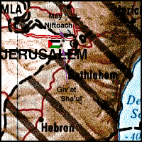
The village was built on the eastern slopes of a hill, the peak of which was some 800 meters in height and commanded a wide view all around. It faced the western suburbs of Jerusalem (approx. location at  on map)--about 1 km away--from which it was divided by a terraced valley planted with fig, almond, and olive trees. Along the northern rim of the valley ran a secondary road that linked Dayr Yasin to these suburbs and to the main Jerusalem-Jaffa road 2 km to the north. Dayr means "monastery" in Arabic. This was not an uncommon component of Palestinian village names and is hardly surprising in a village so close to Jerusalem. There was in fact a large ruin at the southwestern edge of the village which was known simply as the "Dayr."
It appears that the nucleus of the settlement in early Ottoman times was at Khirbat Ayn al-Tut--"The Mulberry Spring Khirba"--some 500 meters to the west of the village site. In 1596 the village of Khirbat Ayn al-Tut was in the nahiya and liwa' of Jerusalem with a population thirty-nine. It paid taxes on wheat, barley, and olive trees.
The approximate date when settlement shifted to Dayr Yasin is not known, but it is obvious that the name is partly derived from a Shaykh Yasin whose tomb stood close to the ruins of the Dayr. Little is known about Shaykh Yasin or about when the mosque bearing his name and tomb was built.
In the late nineteenth century, most of Dayr Yasin's sturdily constructed stone houses were crowded together in a small area known as the Hara ("Quarter"). Two springs, one to the north and the other to the south, provided the village with water. All the inhabitants of Dayr Yasin were Muslim. In 1906 the westernmost Jewish suburb of Jerusalem, Giv'at Sha'ul, was built across the valley from Dayr Yasin, followed respectively by Monteflore, Beit Hakerem and Yefenof. The secondary road linking Dayr Yasin to Jerusalem and the road to Jaffa ran through Givat Sha'ul.
During World War I the Ottomans fortified the hilltop near Dayr Yasin as part of the defense system of Jerusalem. On December 1917, these fortifications were stormed by troops under the command of General Allenby in the final offensive that led, on the following day, to the fall of Jerusalem into Allied hands.
Until the 1920s, Dayr Yasin's livelihood largely depended on agriculture, supplemented by livestock, but the building boom in Jerusalem under the Mandate changed the basis of its economy. The area around Yasin was rich in limestone--the favored building material in Jerusalem. Early in the Mandate, the villagers excavated extensive quarries along the length of the secondary road leading to the city, and developed an increasingly thriving industry in stone cutting and processing. The influx of capital encouraged the more prosperous villagers to invest in business like trucking, and in 1935, a local bus company was established in a joint venture with the neighboring village of Lifta (Jerusalem District). As Dayr Yasin prospered, its houses radiated from the Hara uphill and eastward, towards Jerusalem.
In the early days of the Mandate, the village had no school of its own and its children attended school at Lifta or Qalundya (Jerusalem District). By the mid-1940s, the donations of villagers had financed the construction of two elementary schools (one for boys, and one for girls). The village also had a bakery, two guest-houses, a social club ("The Renaissance Club"), a thrift fund, three shops, four wells, and a second mosque on the slopes overlooking the village (donated by Mahmud Salah, an affluent villager). By the end of the Mandate, many villagers were employed outside Dayr Yasin as waiters, carpenters, and foremen in nearby British army camps, or as clerks and teachers in the Mandatory civil service. In 1948, no more than 15 percent of the village population was engaged in agriculture.
Dayr Yasin's population had increased from 428 in 1931 to 750 in 1948, as had the number of houses (from 91 to 144). Relations between the village and its immigrant Jewish neighbors had started reasonably well under the Ottomans, perhaps because the first to settle nearby were Arabic-speaking Yemeni Jews. Relations deteriorated as tensions increased between Jews and Arabs increase during the British Mandate, and reached its pre-WWII nadir during the Great Rebellion of 1936-39. During the boom years of 1939-1945, however, peaceful relations were re-established, so that in 1948, Dayr Yasin was a prosperous, expanding village with friendly business and social relations with its Jewish neighbors.
Occupation and Depopulation
Dayr Yasin was the site of the best-known and perhaps bloodiest atrocity of the war. Although the massacre was carried out by the Irgun Zvai Leumi (IZL) and the Stern Gang (LEHI)--paramilitary groups whose operations were semi-independent from Jewish Agency/Haganah leadership--the occupation of the village fell within the general framework of the Haganah's Operation Nachshon. The History of the Haganah states that David Shaltiel, the Haganah's Jerusalem commander, learned of the IZL-LEHI plan to attack Dayr Yasin, and informed IZL-LEHI commanders that--despite a non-aggression pact signed with Dayr Yasin leaders--the occupation and retention of the village was a part of the general Haganah plan in Operation Nachshon. Shaltiel warned, however, that if IZL-LEHI forces prove unable to hold onto the village, partially destroying it upon upon withdrawal would only encourage the enemy to convert Dayr Yasin into a military base. Shaltiel later conceded that, in response to requests made in the course of the attack, he had supplied the attacking units with ammunition and mortar cover after villagers turned back the initial assault. (The New York Times reported that, "twenty men of the [Jewish] Agency's Haganah militia reinforced fifty-five Irgunists and forty-five Sternists who seized the village".)
The Haganah stated that at dawn on 9 April 1948, 120 men (80 from IZL and 40 from LEHI) began an assault on the village. The History of the Haganah mentions that they carried out the massacre,
"...without discriminating among men and women, children and old people. They finished their work by loading some of the 'prisoners' who had fallen into their hands onto cars and parading them in streets of Jerusalem in a 'victory convoy,' amidst the cheers of the Jewish masses. After that, these 'prisoners' were returned to the village and killed. The victims included men, women, and children, a total of 245 people."
The New York Times reported that about half of the victims were women and children; another 70 women and children from the village were carried off and later turned over to the British army in Jerusalem.
After the massacre, the Irgunists and Sternists escorted a party of U.S. correspondents, including one from The New York Times, to a house at the nearby settlement of Giv'at Sha'ul. Over tea and cookies, the perpetrators "amplified the details" of the operation. They said that ten houses had been blown up in the village and that the attackers blew open doors and threw hand-grenades into others. A spokesman for the attacks said that the village was "under control" within two hours, adding that he expected the Haganah to take over the village. The spokesman's claim was contradicted by the fact that IZL-LEHI forces appealed to the Haganah for help. The New York Times reported initially that the Haganah took over the occupation of Dayr Yasin the day after the massacre, on 10 April, but later said that the Haganah formally occupied the village on 11 April.
The massacre was condemned by the leading Jewish authorities, including the Haganah, the Jewish Agency and the Chief Rabbinate. Dayr Yasin soon became a byword for the atrocities committed during 1948, and the impact the massacre had on provoking the exodus of Palestinians afterwards has become the subject of intense controversy in Israeli and Palestinian circles. The literature on the Dayr Yasin massacre in Hebrew, English, and Arabic is voluminous.
Click here to read a "Red Cross Eye-Witness Report on the Dayr Yasin Massacre"
Click here to visit the Dayr Yasin Website
In the summer of 1949 several hundred Jewish immigrants settled near Dayr Yasin in Givat Sha'ul Bet, named after the older settlement of Giv'at Sha'ul which was established in 1906. Four prominent Israeli intellectuals wrote to Ben-Gurion, asking that the land be left empty as a "terrible and tragic symbol," but the repeated appeals went unanswered. Present at the Giv'at Sha'ul Bet dedication ceremony were several cabinet ministers, the two chief rabbis of Israel, and the Jewish mayor of Jerusalem. The Israeli neighborhood of Giv'at Sha'ul has now spread over the eastern sector of the village (Return to map above).
Many of the village houses on the hill are still standing and have been incorporated into an Israeli hospital for the mentally ill. Some houses outside hospital grounds are used for residential and commercial purposes, or as warehouses. Outside the fence, there are carob and almond trees and the stumps of olive trees. Several wells are located at the southwestern edge of the site. The old village cemetery, southeast of the site, is unkempt and threatened by debris from a ring road that has been constructed around the village hill. One tall cypress tree still stands at the center of the cemetery.
Return to Destroyed Palestinian Villages index.
| About CRDPS | Race Against Time Project | CRDPS Archives |
| Complete Guide to Palestine's Websites - Academic & Research listings |
Material compiled by Rami Nashashibi, June 1996.
Page design by Birzeit Web Team, March 1997.
Center for Research and Documentation of Palestinian Society, Birzeit University, P.O. Box 14, Birzeit, West Bank, Palestine.
Tel: +972-2-998-2975, Fax: +972-2-995-2975, E-mail: center@research.birzeit.edu.