href="
Destroyed Palestinian Villages:
A Reign of Terror & Systematic Expulsion
Miska
The village of Miska stood on a slightly-elevated sandy hill on the coastal plain, along the north bank of a wadi (approx. location at  on map). It was linked by secondary roads to the highway leading to Tulkarm and to the coastal highway. The village may have been founded by descendants of the Arabian tribe of Miska whose members immigrated to the area prior to, and in the early days of, the Islamic conquest. Another village with the same name but at a different location existed in 1596, in the nahiya of Jabal Shami (liwa' of Nablus). According to the Arab chronicler al-Safadi, a number of Islamic scholars have attributed their origins to Miska, including the grammarian and prosodist 'Abd al-Mun'im al-Miski (al-Iskandarani), who died in Cairo in 1235. According to the Arab geographer Yaqut al-Hamawi (d. 1228), Miska was also known for its fruit, especially the misk (musk) apple variety which was said to have been transferred to Egypt by the Fatimid Vizier al-Hasan al-Yazuri (d. 1058). The French commander Kleber and his troops passed by the village on their way to Acre during the Napoleonic invasion in 1799.
In the late nineteenth century, Miska's population was estimated at 300. Olive trees were planted to the north and south, and fig and palm trees were scattered throughout the village. The plan of the village was roughly square and was divided into four unequal sections by two streets that intersected at the village center. New houses, built in the last years of the British Mandate, were located to the north, away from the wadi. The residents of the village were Muslim, and maintained a mosque and an elementary school. Some parts of the surrounding lands had been forests but had been cleared and planted with fruit trees. Water resources, especially wells, were relatively abundant around the village, and helped support the village's large citrus orchards. In 1944 a total of 1,115 dunums was devoted to citrus and bananas and 3,245 to cereals. An additional 304 dunums were utilized for the growing of other fruit trees. Grain, greens, cucumbers, and watermelons were also grown. To the southwest of the site lies a prehistoric, manmade hill, Dhahrat al-Sawwana--evidence of long-term settlement.
Occupation and
Depopulation
Haganah officers reportedly ordered the villagers to leave on 15 April 1948, but the order was not heeded. A few days later, on 20-21 April, units of the Alexandroni Brigade attacked Miska and forcibly expelled its inhabitants. This was done within the framework of an earlier decision by the Haganah command to ensure the evacuation of all Arab communities from the coastal area between Tel Aviv and Zikhron Ya'aqov south of Haifa in the weeks before 15 May. In early June, Israel set about destroying this village, along with a number of others. This was done despite some opposition from the left-wing Israeli party Mapam. By 16 June, Israeli prime minister Ben-Gurion was able to write in his diary that the destruction of Miska was proceeding. However, Ben-Gurion carefully avoided giving written permission for the destruction of Miska and other villages, presumably to avoid implication in the action.
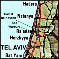
Sde Warburg was established in 1938 on lands that had traditionally belonged to the village. Mishmeret, established in 1946, is also close to the site, to the northwest, on village lands. Ramat ha-Kovesh, founded in 1932, is about 1 km due west of the site, though not on village lands (Return to map above).
The site is covered with citrus groves bordered by cacti. The two-room school still stands and is used as a barracks for guards, while the mosque is used for storage. Large cement fragments of the village well are still visible. Most of the surrounding land has been planted with citrus trees.
Return to Destroyed Palestinian Villages index.
| About CRDPS | Race Against Time Project | CRDPS Archives |
| Complete Guide to Palestine's Websites - Academic & Research listings |
Material compiled by Rami Nashashibi, June 1996.
Page design by Birzeit Web Team, March 1997.
Center for Research and Documentation of Palestinian Society, Birzeit University, P.O. Box 14, Birzeit, West Bank, Palestine.
Tel: +972-2-998-2975, Fax: +972-2-995-2975, E-mail: center@research.birzeit.edu.