The Archive Pages
Destroyed Palestinian Villages:
A Reign of Terror & Systematic Expulsion
A Reign of Terror & Systematic Expulsion
Lubya
Before 1948 |
Occupation & Depopulation |
Israeli Settlement |
The Village Today |
Lubya Before 1948
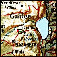
The village of Lubya was located on the summit of a rectangular, rocky hill that extended in an east-west direction and overlooked the plain of Tar'an to the south (approx. location at  on map). It was divided into eastern and western parts by a secondary road that linked it to the Tiberias-Nazareth highway. The Crusaders knew the village as Lubia. Lubya was said to be the hometown of Abu Bakr al-Lubyani, a prominent Muslim scholar of the fifteenth century who taught Islamic religious sciences in Damascus. In 1596, Lubya was a village in the nahiya of Tiberias (liwa' of Safad) with a population of 1,177. It paid taxes on goats, beehives, and on a press that was used for processing either olives or grapes. The governor of Damascus, Sulayman Pasha, died in Lubya in 1743 on his way to confront Zahir al-'Umar, who became the de facto ruler of northern Palestine for a short period in the second half of the eighteenth century. In the early nineteenth century the British traveler Buckingham described Lubya as a very large village on top of a high hill. The Swiss traveller Burckhardt noted in 1822 that wild artichokes covered the plain where the village was located.
Later in the nineteenth century, Lubya's population was estimated variously at 400 to 700, and was employed in the cultivation of olive and fig trees. The older stone houses were clustered on the eastern side of the site (as were the newer buildings constructed during the British Mandate), possibly because the eastern side of the hill overlooked the cultivated lands of the village. The villagers were predominantly Muslim. An elementary school was established in the village in 1895, and remained in use during the British Mandate. During the Mandate period, Lubya was the second largest village in Tiberias District in terms of area.
The village economy was based on agriculture--its lands were fertile, and it was known in the region for its high quality wheat. In 1944/45 a total of 31,026 dunums were allotted to cereals, and 1,655 to orchards and olives.
Lubya also had importance archeologically--two km to the east of the village were the ruins of a structure known as Khan Lubya that contained the remains of a pool, cisterns, and large building stones. This site was probably a caravansary during medieval times.
Occupation and Depopulation
The Palestinian press reported an attack by Zionist forces on Lubya during the night of 20 January 1948, which left one villager dead. This early raid was coordinated with another on the nearby village of Tur'an, according to an account in the newspaper Filastin. A 24 February skirmish with a Jewish convoy on the outskirts of the town lasted four hours and, according to the account in Filastin, left one Arab dead and two wounded, in addition to many casualties in the convoy. A third attack took place during the first week of March 1948. Palestinian historian 'Arif al-'Arif states that Haganah soldiers attempted to force their way through the road between Tiberias and al-Shajara, attacking Lubya at dawn. They reached the western edge of the village but were repulsed by the villagers themselves, who lost six men while killing seven of the attackers. Filastin reported another infiltration attempt on 11 March that was preceded by mortar shelling.
With the occupation of Tiberias in mid-April 1948, the people of Lubya were isolated and turned to Nazareth for help and guidance, according to the recollections of the villagers themselves. They told Palestinian historian Nafez Nazzal that there was another attack on Lubya on 10-11 June, as the first truce of the war was about to go into effect. At the same time, the Arab Liberation Army (ALA) attacked the Israeli settlement of Sejera to the southwest. Villagers recalled that an Israeli infantry unit took up positions at the southern end of the village, but withdrew by nightfall on 11 June. The village militia participated briefly in the fighting at Sejera with the ALA, but returned to protect the village during the truce.
After the truce ended, Israeli forces launched Operation Dekel. On 16 July, some villagers brought the news of the fall of Nazareth. In the words of former residents of Lubya interviewed some twenty-five years later, the village was "terrified," but their request for military aid from the ALA was turned down. During the night of 16 July, most of the population fled northwest towards Lebanon, leaving behind the village militia and some elderly people. When an Israeli armored unit approached the following day, the poorly-armed militia decided to retreat. Eyewitnesses said that the occupying force shelled the village before entering it, and then destroyed a number of houses and commandeered some others. Some elderly people took refuge in a nearby cave and a few later escaped--the fate of the rest is unknown. "Lubiya fell without fighting," the History of the War of Independence states, "and the road to Tiberias was open to us."
Israeli Settlements on Village Lands
The settlement of Lavi was established on village lands in 1949 (Return to map above).
The Village Today
The Lavi pine forest has been planted by the Jewish National Fund--the body of the World Zionist Organization in charge of land acquisition and development--on the western side of the site. Another forest has been planted nearby in the name of the Republic of South Africa. The debris of the houses is buried under these forests. Cacti, scattered cisterns (formerly were used by the villagers for collecting rainwater), and pomegranate and fig trees further mark the site. The lands around the site are cultivated by the nearby settlement. A forest and a military museum have been established near the site in honor of the Golani Brigade of the Israeli army. The secondary road that once led from the village to the Tiberias-Nazareth highway is still recognizable.
| Complete Guide to Palestine's Websites - Academic & Research listings |
Material compiled by Rami Nashashibi, June 1996.
Page design by Birzeit Web Team, March 1997.
Center for Research and Documentation of Palestinian Society, Birzeit University, P.O. Box 14, Birzeit, West Bank, Palestine.
Tel: +972-2-998-2975, Fax: +972-2-995-2975, E-mail: center@research.birzeit.edu.