

Khirbet Birzeit 1996, 1998-1999: Preliminary ResultsAn article published in Journal of Palestinian Archaeology, a publication by Palestinian Institute of Archaeology of Birzeit University, Volume I, Number 1, January 2000By Khaled Nashef
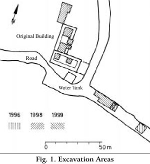
Although the excavations did not yield up till now any architectural remains from the Iron Age, the evidence from three seasons of excavation (1996, 1998- 1999) conforms with the above- mentioned observations. With respect to the subsistence economy of the site (1998 season) and its habitation (1999 season), Khirbet Birzeit represents a site of some significance in the Byzantine period. It seems that this situation continues through the Umayyad period (1996, 1999 seasons). A unique condition developed in the Mamluk period, reflected by the public nature of the free- standing structure at the highest point of the site (819.20 m above sea level). Two halls of this building, which is designated here as the Original Building (el- Baubariyya[ t], see below), were excavated and largely uncovered down to the bedrock (1998, 1999). There may have been some installations connected with the Original Building to the east according to evidence from the 1996 season (similar vaulted rooms and building techniques). The excavations have not revealed any conclusive evidence which may date the Original Building or any other remains to the Frankish period The limited excavated areas and their distribution (see Fig. 1) do
not allow one to draw comprehensive results with respect to the nature
of settlement at Khirbet Birzeit or its size during the Byzantine or
Late Islamic periods. However, it is possible to advance some hypotheses,
modifying earlier views: First, it seems that there has been at Khirbet
Birzeit a continuity from the Iron Age (I) up to the Byzantine period
reflected in the subsistence economy of the site. This is supported
by the existence of a wine press cut in the bedrock near the region
where the Iron Age habitation is postulated, that is, in the western
slope of the hill2. This wine press lies southwest of the Original
Building (see Fig. 2).
Al-Yamani The continuous use of the Original Building came to an end by the later phase of the Mamluk or the beginning of the Ottoman period. According to oral tradition, the Khirbet had been abandoned by the beginning of the Ottoman period, when the inhabitants moved to the village of Birzeit. This is supported by the existence of late architectural finds uncovered during the 1998 season within the Original Building indicating a secondary or seasonal use of the area. There are also within the Building partition walls dividing lots belonging to various families from Birzeit (see above, p. 4). It has been assumed that Khirbet Birzeit, along with Birzeit itself, represents the main Islamic site of the early Ottoman period. The results of the excavations (secondary and isolated uses in the Ottoman period) cannot reflect the situation conveyed by the Ottoman records at the end of the 16th century4. It seems more likely that the latter refers to the village of Birzeit, and not the Khirbet. The strong Hellenistic component at Birzeit (33 % compared with 2.3 % at the Khirbet) gives support to the identification of Birzeit, the town, with Birzetho of the second century B. C. This implies a confusion of place names in I Maccabeus, and that Berea (possibly el- Bireh) should be excluded from the historical geographic discussion. Birzeit lay on the Roman road connecting Jifna (Gophna) with Ras el- c Ain (Antipatris)5, and, consequently, Khirbet Birzeit may have represented a bastion (note the high location) in the Byzantine period in connection with Birzeit. It is noteworthy that Khirbet Birzeit bears another name, el- Mamsiyya( t), as maintained by the inhabitants of Birzeit. This name has not been explained till now6. The agricultural economy at Khirbet Birzeit depends on horticulture, especially vineyards in the older periods (Iron to Byzantine), as indicated by the two wine presses found at the site (see above). It is clear, however, that the basic economy of the later periods was the production of olive oil, which was concentrated in Birzeit itself, as the Ottoman records reveal7, and in conformity with modern times. In the region designated as "the Southern Slopes"8, oil presses constitute 68 % of the total number of such presses in the larger area comprising other regions to the south of Nablus. There is a high rate of such presses in the surroundings of Birzeit itself9. This conforms with the name Birzeit which goes back to Aramaic Beirzeitha. The implication of Bir (" well") could be rock- cut containers of oil presses for collecting the oil. The word has been applied to designate the village as a whole10. In previous studies, the Original Building had been dated to the Frankish period according to comparisons of its general form (semi- fortification, courtyard) to a type of building common in the Palestinian countryside. A group of these buildings has the Palestinian name el- Baubariya( t), a word connected with Old French Boverie, which means "cow- shed" or the like11. This association is highly conjectural and should be taken with caution. According to recent estimations, rural sites and buildings such as Khirbet Birzeit, which have been dated to the Frankish period, amounts to 540 sites. This is taken to reflect relatively secure conditions in the Latin Kingdom in connection with the castles as administrative centers12. However, only a few of these sites have been excavated13. Khirbet el- Lawza, some 8 km northwest of Jerusalem, has some common features with Khirbet Birzeit. Only limited archaeological investigation was conducted Journal of Palestinian Archaeology I/ 1, January 2000 3 at the site in 1996. The excavation has not yielded clear evidence for the construction date of the main building14. A hypothetical relation between Khirbet el- Lawza and an- Nabi Samuwel (Mons Gaudii of the Frankish period) could be compared to the relation between Khirbet Birzeit and Jifna. No clear archaeological evidence has been produced for dating Jifna in the Frankish period, although it is mentioned once in the Frankish sources. At least one large hall at Jifna (designated there as el- Baubariyyah, it is worthwhile to note) could be compared with the southern and possibly the northern hall of Khirbet Birzeit15. According to conclusions reached during the excavation seasons 1998 and 1999, the Original Building at Khirbet Birzeit was constructed directly on the rock- cut installations from the Byzantine period. These were sealed in the Mamluk period (see p. 7, fig. 3, 11, fig. 9). It follows that the construction date of the Original Building predates its use in the Mamluk period, and should fall within a period extending from the abandonment of the agricultural installations in the Byzantine period to the early part of the Mamluk period It is difficult to determine the function of the Original Building16. If it is dated to the Frankish period, it could belong to buildings which one may identify "as the house of lesser knight or sergeant, equivalent to the maisons fortes ... of the West" or "as estate centres (curiae), occupied by the stewards who administered the lands of the absentee secular or ecclesiastical land- owners" (Pringle 1997: 11). Nevertheless, no typical finds were uncovered within the buildings which could be dated to the Frankish period, and this fact renders at least some of these assumptions less probable. In the Mamluk period the Building could have served as the administrative center of a local feudal lord. Notes
BibliographyAbel, F.- M.
Abel, F.- M.
Allush, M.
Boas, A.
Ellenblum, R.
Ellenblum, R.
Ellenblum, R., Rubin, R., and Solar, G.
Finkelstein, I.
Finkelstein, I., Lederman, Z., and Bunimovitz, S., eds.
Khalidi, T.,
Pringle, D.
|
 return to society |
 Khirbet
Birzeit is a multi- period site with an occupation extending from the
Iron Age to the Ottoman period
Khirbet
Birzeit is a multi- period site with an occupation extending from the
Iron Age to the Ottoman period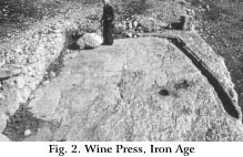 Second, the Byzantine agricultural installations including a wine press
to the north of the Original Building (1998 season) covers a large area
of the hilltop, at least to the north, beneath the Original Building,
and to the south under the present water tank (see Fig. 3 before the
construction of the water tank). Third, there are in the Khirbet a number
of ancient wells. Although they have not been investigated, this indicates
production activities going beyond the mere fulfilling of one's own
needs. Finally, the Byzantine occupation concentrated to the east of
the Original Building, and, accordingly, to the east of the agricultural
installations belonging to the Byzantine town. The third season revealed
parts of the ground floor of residential quarters comprising several
rooms
Second, the Byzantine agricultural installations including a wine press
to the north of the Original Building (1998 season) covers a large area
of the hilltop, at least to the north, beneath the Original Building,
and to the south under the present water tank (see Fig. 3 before the
construction of the water tank). Third, there are in the Khirbet a number
of ancient wells. Although they have not been investigated, this indicates
production activities going beyond the mere fulfilling of one's own
needs. Finally, the Byzantine occupation concentrated to the east of
the Original Building, and, accordingly, to the east of the agricultural
installations belonging to the Byzantine town. The third season revealed
parts of the ground floor of residential quarters comprising several
rooms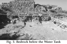 The
Byzantine settlement continued through the Umayyad period according
to the results of the first and third seasons. This period seems to
be concentrated on the eastern slope of the hill, and represents an
extension of the previous phase. There seems to be a decline in the
Abbasid (and Fatimid) periods which may be attributed to insecure conditions
in Palestine during these periods (for the Abbasid period note the movement
of Abu Harb in the north; see Khalidi 1984: 184- 185).
The
Byzantine settlement continued through the Umayyad period according
to the results of the first and third seasons. This period seems to
be concentrated on the eastern slope of the hill, and represents an
extension of the previous phase. There seems to be a decline in the
Abbasid (and Fatimid) periods which may be attributed to insecure conditions
in Palestine during these periods (for the Abbasid period note the movement
of Abu Harb in the north; see Khalidi 1984: 184- 185).