Oslo 2 Diary
5 January 1996
Why have the maps changed?
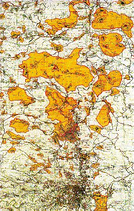
Carribean Islands?
It was the beginning of January when I first got hold of a copy of the Oslo 2 maps and had a chance to study them in detail. They looked like a navigator's map of the Carribean. The section on the left (hi-res double load image) (the whole map a little too large for my scanner) shows the West Bank above Jerusalem (the black city at the bottom), almost all the way up to Nablus (off the map, just above the swan-shaped yellow part at the top).
It is important to note that on this, the official Oslo 2 map, the Israeli cartographer has pulled a fast one. Area A is a light orange colour, while Area B is yellow. It is important not to confuse the two areas. Area A is the Palestinian autonomous areas. Area B hass minor Palestinian administration plus overall Israeli control of security. Two very different things. The only part of Area A visible on this section is the Ramallah/Al-Bireh district (roughly central on the map). Area C - everything else - is under full Israeli sovereignty, of course.
Area A includes (from north to south) Jenin, Tulkaram, Nablus, Jericho, Ramallah/Al-Bireh, Bethlehem/Beit Sahour, and half of Hebron. The Palestinians now have 1,950 square kilometres of the West Bank and Gaza but Israel, including the settlers who are outnumbered almost 8 to 1, maintains sovereignty over two-thirds of the land.
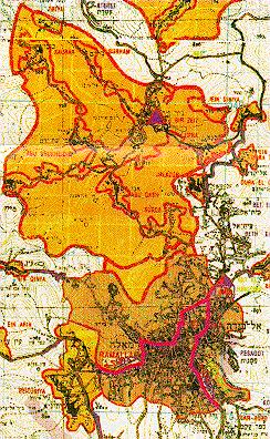
Ramallah/Al-Bireh area
Let's have a closer look. The merged towns of Ramallah and the smaller Al-Bireh are represented by an orange Area A on the map (at the bottom). The purple triangle with a red border, in the yellow Area B above this, is the police station in Birzeit village. Birzeit University, where I work, is a small distance back down the road towards Ramallah. On the map, it's that small, diamond-shaped road pattern right in the middle of the yellow section, at the node of the mysterious red lines. Who knows what the red lines mean? They're not roads.With the University and Ramallah in different areas, we forsaw problems. A huge percentage of the students, staff and faculty live in Ramallah. The Gaza Strip, all on its own between Egypt, pre-67 Israel and the sea, is subjected by Israel to economically-devistating punitive closures on a regular basis. What had us worried was Oslo 2's similar defining of seperate little territorial units on the West Bank.
Jericho, our model for this since the May 1994 implementation "Gaza-Jericho first", had indeed been closed for a few days here and there. A short time after Jenin experienced redeployment (before Ramallah), it too had suffered a punitive closure. We were not wrong. On 12 February 1996, Ramallah and Birzeit were cut off from each other by an Israeli checkpoint. This paralysed the University. It happened again on 5 March 1996, in the wake of bomb attacks by Palestinian extremists in Jerusalem and Tel Aviv, and University life has been halted right up to the time of writing this, on 13 March. This has been one of the sad realities of the peace deal.
NB: For more recent diary entries on these realities of the Oslo 2 map, manifest in its subsequent implementation, check out the rest of the entries in the Discovering Oslo 2 Diary!
Click Here for DIARY INDEX
The full size Oslo 2 map can be ordered from the Jerusalem Media and Communications Centre (e-mail:jmcc@baraka.org)